We've been teaching my kids about "the continents" and to the credit of my kid he asked me "what makes a continent?" Off the top of my head I didn't know precisely where the definition came from. I did however love the fact that my 5 year old has enough sense to ask why this thing is a thing. So I looked it up. Turns out the whole thing makes as much sense as a football bat.
Even after reading up on it I still can't figure out for the life of me why we have 7 continents. To be fair, when I say "we" I am talking about the American/ Western European model. There are other models, but they also feel pretty silly. Here are the most common continent models right now:
- 6 continents (The United Nations): Africa, Asia, Europe, "Americas", Antartica, Australia. This is taught mostly in Greece and Latin America according to wikipedia
- 6 continents (Russia/ Eastern Europe): Africa, Eurasia, North America, South America, Antartica, Australia
- 5 continent model: the 6 (UN) continent model but it just removes Antartica due to the fact that people don't live there.
- 5 continent model: A different 5 continent model just kinda says fuck it and starts combining things randomly (like Africa and Europe?)
- 4 continent model: cause why not?
- And there is an 8 content model which arbitrarily includes Zealandia, a submerged landmass that is large, but its also only like ~700,000 square miles bigger than the indian sub-continent, has no people, isn't a tectonic plate.
Oddly, the only pre-existing one that sort of makes sense to me is the 6-continent geological/ Russian model. They have Africa, Eurasia, North America, South America, Antartica, and Austrailia. This is roughly a geological model. Presumably, they are the largest landmasses on tetonic plates. (See tectonic image below)
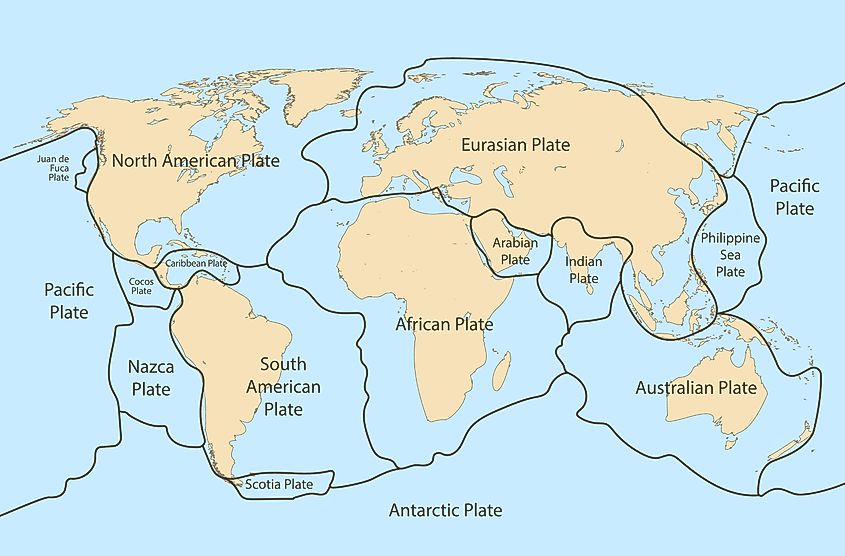
When I look at the status quo, the obvious problem is Europe calling themselves a continent, which is clearly a historic/ cultural legacy situation. Europe is on a contigous plate with Asia, its a relatively small landmass. If you are going to make Europe a continent and keep some level of intellectual consistency you definitely need to add the Indian subcontinent, and probably the Arabian Peninsula/ Greenland.
I think the Europeans are just using good old fashioned marketing by making all the important maps show Europe as larger than it really is...
When I look at the overall situation though, I really don't hate Europe as a continent. It's geographically separated from the other population centers on its tectonic plate, has a large enough landmass, and a large population.
What are continents anyway?
I think all the definitions kind of suck so lets say continents are an organizational tool that help to break down the world into more manageable pieces. By that definition the current models still suck, BUT we can likely build a more consistent model.
Building a better rubric
I get that arguing about the continents is about as useful as turn signals on a bmw. but here's my "I can build a bikeshed" model for you. Feel free to tell me its trash or improve it.
Geology
Separate geologic features such as tectonic plates, continental shelf, make up of the landmass.
Size
At a certain point the size of the landmass and divisibility is really what we're talking about here.
Distance and separation
How "distinct" is the thing. Kansas is a hard sell, but Madagascar is pretty darn separate.
Population
Since the continental model is mostly for organizing things, the population is actually a useful feature.
Definitely Continents
Asia
- 1-3 tectonic plates
- Largest single landmass with or without Europe being included.
- Without Europe - 44,579,000 km2 (17,212,000 sq mi)
- With Europe - 55,000,000 km2 (21,000,000 sq mi)
- Separated from other contents (except potentially for Europe) by oceans. or narrow strips of land.
- 4,694,576,167 people or 5.4 billion (with Europe)
Africa
- Contains 2 tectonic plates with the majority being on one tectonic plate
- Second largest landmass
- 30,370,000 km2 (11,730,000 sq mi)
- Completely separated from other continents by water
- 1,393,676,444 people
North America
- 1 tectonic plate
- 3rd largest landmass
- 24.709 million km2 (9.54 million sq mi)
- Basically separated from other continents by water
- 592,296,233 people
South America
- 1 techonic plate
- 4th largest landmass
- 17,840,000 km2 (6,890,000 sq mi)
- Basically separated from other continents by water
- 434,254,119 people
Probably Continents
Antartica
- 1 tectonic plate
- 5th largest landmass
- 14,200,000 km2 (5,500,000 sq mi)
- Completely separated from other continents by oceans
- 5100 people (summer)
So the population element is really the only point of contention. Does a continent need a population? To me it feels like it shouldn't. When we nuke ourselves into a nuclear winter Antartica will still be just chillin'... Continents should be able to out last people.
Australia/ Oceania
- 1 tectonic plate
- 7th largest landmass
- 8,600,000 km2 (3,300,000 sq mi)
- Separated from other continents by water
- 39,357,469 people
From a landmass standpoint Australia is smaller than Europe, but still larger than The Indian subcontinent (3,287,590 square kilometers (1,269,346 square miles)) or Greenland (2,166,086 square kilometers/ 836,330 square miles)... thats the only knock on it though. Otherwise it fits every other reasonable criteria.
Debatable Continents
India
- Separate tectonic plate
- Large Landmass
- 3,287,590 square kilometers (1,269,346 square miles)
- Not separated by water, but separated by the largest moutains in the world
- 1,463,865,525 people
I think the case for India being a continent is stronger than Europe's case. Yes, it is smaller. The only thing it is missing though is separation by water, but thats basically because the continent or sub-continent is running into another continent (Asia). Sure its a smaller landmass but its still huge - the numbers on the landmass are also hard to get with a quick google search... since the sub-continent is crashing into Asia where does one begin and the other end? If population were the determining factor, India would be second only to Eurasia.
Arabian Peninsula
- Separate tectonic plate
- Large Landmass
- 3,237,500 km² (1,250,000 sq mi)
- Mostly separate from other landmasses by water
- 77,983,936 people
Similar to the Indian sub-continent the Arabian Peninsula has many features of a contient, probably more than Europe. It is on its own tectonic plate, it is a large landmass, and has a large population. It is however joined with Europe in that it branches off of Asia and is less distinct.
Europe
- Not a tectonic plate
- 6th largest "landmass"
- 10,000,000 km2 (3,900,000 sq mi)
- Not separated from other landmasses by water (Asia, Arabian Peninsula), but separated by mountains.
- 744,398,832 people
Lets pretend our criteria were strict and at least 3/4 were required and strong cases... Europe shouldn't be in, but lets be real... its its own thing. It's big enough and separate enough it should be able to be considered a continent. The problem with that is, where do we draw the line on size, population, and geographic separation... Does the Sahara warrant being its own continent? Its larger than Europe. If we are going to call Europe a continent India DEFINITELY needs to be a continent, and probably the Arabian Peninsula.
Probably Not Continents
Greenland
- Not a tectonic plate
- Large Landmass
- 2,166,086 square kilometers/ 836,330 square miles
- Separate from other landmasses by water
- 56,583 people
With climate change this should become a renewed argument.
Zealandia
- Not a tectonic plate
- 8th largest "landmass"
- 10,000,000 km2 (3,900,000 sq mi)
- Covered by water
- (0) population
Really not sure how this thing slips into the literature other than its kind of big.
Should we really care about this?
Well I'm now ~1400 words deep on a topic I really don't care that much about. This came around because we've been teaching my kids about the contenients and I'm having a tough time explaining Europe as a continent without India or the Arabian Penninsula being in the same classification. Even my 5 year old has enough sense to be like: "that doesn't really make sense"... and he's right.
With that said even if all OECD countries decided to change the definition of what a continent is in every school across the world its really not going to impact my life in any meaningful way.
The only reason I really care is that we keep rolling with something that is so fabulously wrong and telling people that its right (technically theres no real criteria so whatever they say is right, but still)
I don't care if the number we use is 4 (Africa, Asia, North and South America), 6 (Africa, Antartica, Australia, Asia, North and South America), 9 (Africa, Antartica, Australia, Arabia, Asia, North and South America) or 11 (+Greenland & Zealandia) ... I just know the number aint 1, 2, 3, 5, 7, or 15 continents... Like come on?
I know this whole article is ranty, but I feel like we can do better. Just using some basic rubric that has some logic to it would probably work fine.
My only real take away from this is that people are silly, and that we probably have a lot of "facts" that need to be re-evaluated.